Monday, 18 January 2016

The Park - A Rare Gem at Merrion - Part 1

A Rare Survival of a Seventeenth Century Cottage in St. Twynnells, Pembrokeshire

The Distinctive Vernacular Style of Rural South Pembrokeshire


In the late 1970s and early 1980s, I worked, on and off, on the Royal Armoured Corps Range at Castlemartin, Pembrokeshire. It was great! I was a casual Range Warden, which involved putting up targets, manning the sentry posts and lookouts, being a presence on the firing points and a having access to some of the best coastline and countryside in the whole Kingdom! I loved it!

One of the many enjoyable jobs, was accompanying one of the permanent staff wardens - Artie Gough - callsign "Watchdog"- on his regular tasks of checking the gates and boundaries on the range. He was a font of knowledge about the place. Pre-Second World War, he had been one of the gamekeepers on the Stackpole Estate and he told me much about the houses, families, habitats and wildlife of the place.

Amongst one of the places he mentioned, was a cottage called "Park", which whilst not within the range boundary, was a derelict "old house" like many that had been consumed by the War Office in 1939. A good description of these lost buildings is the brief and hurried survey that Sir Cyril Fox undertook just after the War Office moved onto the land at Castlemartin, or as the training area was known then - AFVR Linney Head.

The image below shows one of these cottages - this at Castle Lady in Castlemartin, otherwise known as Drayton.


So, during one lunch hour on the range, I went out through the gates of the camp, crossed the road near Treforce and the sewerage plant that serves the camp at Merrion, and walked up the track to "The Park". Later, that evening, I returned with a camera and took the photograph below. I was very worried that I might be caught!!


The house is aligned roughly North to South. In the photograph, taken from the east, the older part of the house is on the right, with a 19th century addition or rebuilt section to the left, roofed in slate. The northern gable has a large(ish) chimney stack, in this photograph, covered in ivy. To the left of the door is a "lateral" chimney stack, with its upper levels (re?)built in in brick. The corrugated tin roof is an indicator that the cottage was originally thatched, the thatch being replaced, or so I thought, when it became decayed.

At the time, I had just bought " Houses of the Welsh Countryside" by Peter Smith - one of those books that is a landmark in the study vernacular houses ("houses of the people") in Wales and the UK. The Park was an example, in small scale, of one of the typical yeoman farm houses that were, in their time, common-place in the Castlemartin area.

About a quarter of a mile to the south of The Park are two examples of these yeoman farmhouses. The best example is the holiday cottage called Thorne, which sits on the eastern edge of  a small cluster of buildings at a settlement that was known as Hayston. Thorne, until about 1826, was the home of the Moody family, who were copyhold tenants of the Manor of Castlemartin, in the parish of St Twynnells. They had lands scattered all over the parish - as was the norm for many land holders in the area up until the 18th century - their largest parcels being near Vallast Hill and near Trenorgan. The land at Vallast Hill was on Old Red Sandstone, less well drained than the more fertile land at Trenorgan on Carboniferous Limestone. This arrangement was a possible example of how the holdings within the manor were equably distributed across both the good and not so good soils. The Moodys also had rights to the resources of Castlemartin Corse, which was later drained by John Mirehouse of Brownslade. I digress!

The view from St Twynnells church tower in about 1987 of Thorne and Hayston. Thorne is left centre, with part tin roof and Hayston is the large white farmhouse right centre. The Park is just off the picture, bottom left.

Thorne looking from the south-east
Hayston looking from the north-west

The centre ridge chimney stack at Hayston has been much messed around with, but its similarity to the one at Thorne shows that both houses are originally of a similar date. Probably early 17th century, perhaps even late 16th century.

Hayston was improved by the Stackpole Estate as the homestead for a fairly large estate farm, Thorne on the other hand, when relinquished by the Moody family is about 1826, became an estate cottage and was subsequently remodelled into two dwellings. From the north, Thorne reveals more of its pedigree, as shown in the photograph below.


Here we see the fine lateral chimney on the north side of Thorne. The wall on the viewer's side of the stack is that of a lateral out-shut. The tin roof indicates that the older part of the house was probably thatched. The chimney to the far left is part of the nineteenth century conversion of the house into two cottages.


The original door way into the early house, set along side the lateral (on the side of the building) chimney. The later doorway into the second dwelling is to the left. Some rebuilding of walls has taken place too.


The Park has many of the features of Thorne, but on a much smaller scale. Large gable chimney with projecting oven, A lateral fireplace and chimney and a seemingly lateral out-shut.

Other houses locally that seem to embody some of these features, if not all, are mentioned below.

Bosherston, Church Cottage. This was demolished in 1984, but had very many features similar to The Park. It had been overlooked by the planners and conservation bodies and was not listed.


The enigmatic rectangular part projecting from the side wall is either a lateral out-shut, or more likely, the base of a now removed lateral fireplace and chimney. The large stack, covered in dead ivy at the far end of the building, has a semi-circular oven projection, like The Park, (not visible in this photograph). A fuller comparison will be made with The Park in a later post.

Parsons, a very ruinous house in Castlemartin parish, also has a semi-cicirular oven projection. Little remains of the house, but it almost certainly dates form the seventeenth century if records for Castlemartin are to be believed.

The photograph below shows a rough sketch plan of the remains of Parsons about 35 years ago, as surveyed by this blogger.

Parsons, Castlemartin

...and another example of a projecting oven is at Dover, in Bosherston. This is easily visible from the road.


There is also another cottage with a similar oven at Thornston, just down the road towards St Govans Head. This building has similarities to Cold Comfort in Warren.

The projecting oven is believed to be an addition to an earlier chimney stack, and this seems to be the case at The Park, as we will see later.

In the next post on this topic I will look at what I have been able to glean about the history of The Park.

Meanwhile, below is a map to show the locations of the buildings mentioned in this post. All lie on private land.




Tuesday, 14 July 2015

Sway and an Idea for Hospital Bedside Tea.

Having had to visit Withybush Hospital in Haverfordwest lately, the thought below occurred to me!

It is always good to have a cuppa and a chat. Perhaps this idea would make visiting time at hospital seem more like normality for all concerned? Comments welcome.


Tuesday, 14 October 2014

Flash! Flash! Flash! Flash! Flash! (Part 1)


Watching the Birdie!!

How do you take a photograph, from a high speed aircraft at night and at low level? You use a flash!

A lot of my plane spotting, in the 1970s, was carried out from the south facing bathroom window of our house in Pembroke Dock. From here you had an expansive view of the sky towards the Royal Armoured Corps Range (RACR) Castlemartin. This was before the ash trees, with their rookery, became so tall that they blocked the view.


Location of map extracts below in UK

You could not actually see the land surface of the range - that was about 4.5 miles to the south and behind the next row of houses on the skyline 400 yards across the valley. The line of chimney pots provided good markers on the horizon!

We were used to the sound of gun fire from the range and there were usually "night shoots" twice a week, which also lit up the southern sky with orange flashes. However, I soon began to notice that on some nights - often Tuesdays and Thursdays in the winter - that the signature of the "firing" was different. Five equally spaced intense white flashes, followed by five dull thumps. This post is about these flashes and begins to explain what was going on.

Fig. 1: An extract from an Operational Navigation Chart showing Pembrokeshire, Wales, UK
This is from sheet ONC E-1 Edition 8-GSGS (1993)
The chart above shows the important navigation features in and around Pembrokeshire c1993. RACR Castlemartin is the danger area marked "EGD 113". Most of the area is over the sea, with a much smaller portion lying over the Castlemartin peninsula in South Pembrokeshire. The danger area to the east, "EGD 115" is the anti-aircraft artillery range at Manorbier. Pembroke Dock is the yellow blob just above the figure 731 which, incidentally, marks the old smoke stack at the Pembroke Power Station. This stack has now been (spectacularly!) demolished.

Both Royal Air Force (RAF) and United States Air Force (USAF) used the range for night training sorties, as well as the occasional day time mission, often as part of larger exercises and competitions such as Exercise Lifeline and the annual NATO Royal Flush contest.


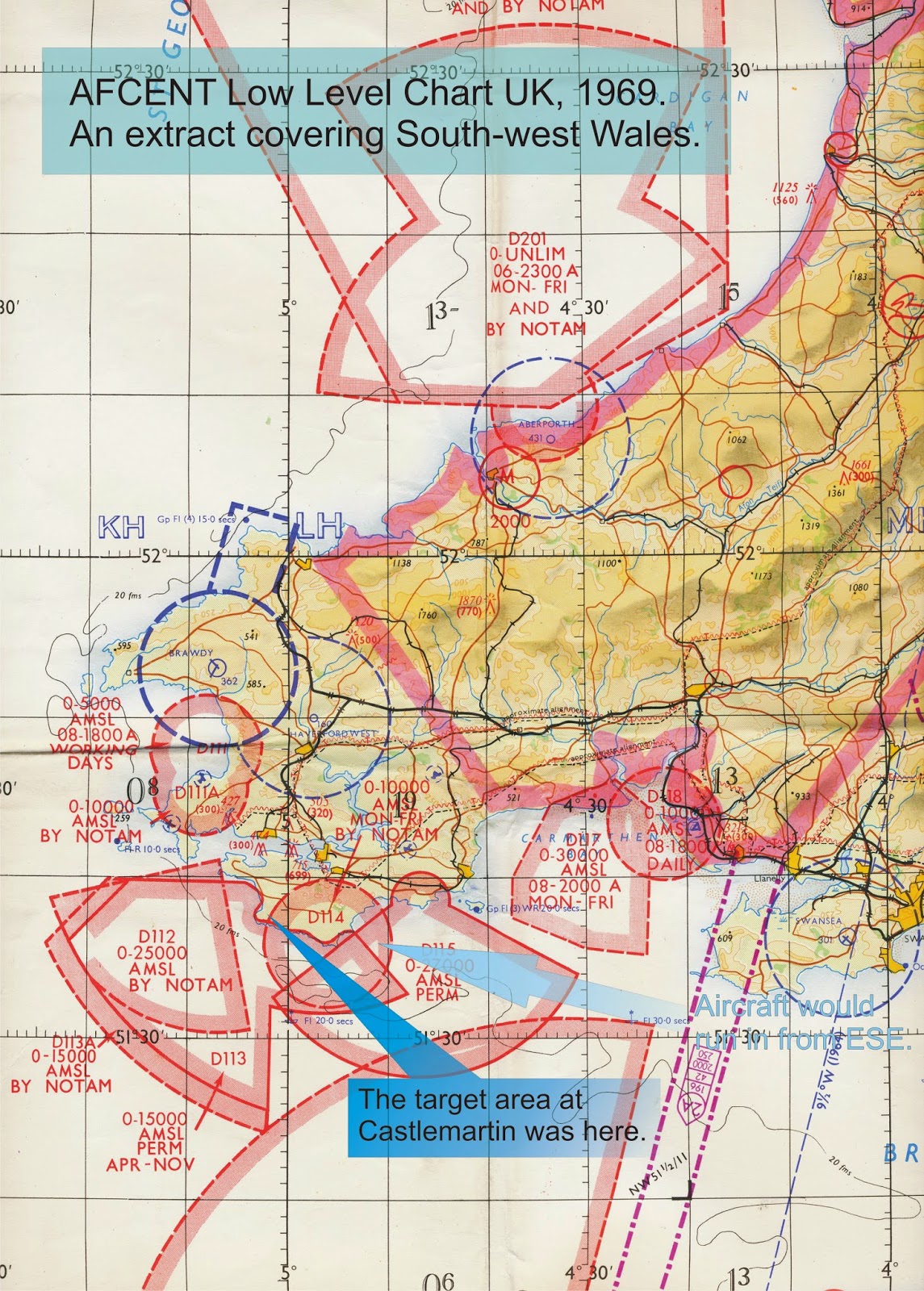
Fig. 2: The layout of ranges around Pembrokeshire in about 1969.
The annotations show the line of approach and the target area at Castlemartin,
which was west of the Warren to Stack Rocks Road, over Range West.

The nights when the range was booked by the RAF or USAF were always published in advance in the "Warning Notice of Firing" for Castlemartin in the local press, so I knew when to hang out of the bathroom window with my metaphorical anorak on!

The American aircraft (RF-4C Phantoms)  often arrived during dusk, before the sky became totally dark. 


Fig. 3: Unit badge of the 1st Tactical Reconnaissance Squadron,
one of the constituent units of the 10th TRW
They were usually from the 10th Tactical Reconnaissance Wing (TRW) at RAF Alconbury in what was then Huntingdonshire. The 26th TRW from Zweibrucken in West Germany probably also used Castlemartin, but I cannot be sure.

The RAF always arrived on scene long after the sun had set.The aircraft were Canberra PR Mk 7s or PR Mk 9s from RAF Wyton, just down the road from the Americans at Alconbury, or the RAF "clutch" airfields in West Germany - Laarbruch, Gutersloh and Wilderath.


Fig. 4: RF-4C of 10th TRW getting airborne from RAF Alconbury.
Notice the grey/white naval style colour scheme and
buzz number FJ-077. c1965
The sorties first started in about 1965. At this time the 10th TRW at Alconbury were just receiving their brand new RF-4C Phantoms, which at the time had a grey/white scheme complete with old style "Buzz numbers" on the fuselage.

To the right  (Fig. 4) is a photograph of such an aircraft getting airborne from its home base in Huntingdonshire.

The RAF sorties were flown by various versions of the Canberra. The photograph below (Fig. 5) shows the PR Mk. 7 version of this long-serving type.


Fig. 5: Canberra PR Mk 7, in a camouflage scheme worn at
the end of its RAF career.

For more information about the Canberra and its photo reconnaissance role in the RAF see the website below.

http://www.airrecce.co.uk/postww2/ac/Canberra/Canberra.html


Fig. 6: 13(PR) Sqn, RAF - their Canberra PR Mk. 9s were the last RAF Canberras to carry out photo-flash sorties.

In the second part of this post I will describe what went on over the range in more detail.


Tuesday, 5 August 2014

A Fitting Tribute.........

The Little Bromley War Memorial

Please see after the ad. below.


Little Bromley is, as its name implies a small settlement in North Essex, so far north it is nearly in Suffolk, so it can be included in this blog post!

At a junction in the main road that passes through the village is a typical triangular piece of land, no more than 10 yards long on each side, that divides the traffic joining the main road, filtering some north and some south.

This image of the memorial in Little Bromley before refurbishment.
Almost the entire area of this "island" is taken up by the war memorial. The local community realised that the memorial was beginning to look a little worse for wear and even neglected. They decided to do something about it, and the link below tells the story of how they began to raise the money to once again return the memorial to its former glory.

Raising Money for the refurbishment

Imperial War Museum has a record for this memorial here.


Today, on the 4 August, I felt it was appropriate to share what has become a most fitting way of remembering the fallen of Little Bromley in the Great War, exactly one hundred years after the start of the conflict.

The photographs I have taken today, and are shown below, show just what a good example the residents of this community have set for others to follow. 


Thursday, 26 June 2014

World Cup Football Creche in Essex

Haircut in Manningtree


I went to have a haircut today. I was starting to look like the mad scientist in "Back to the Future" and the kids in school were starting to comment. 

My policy is to have a low maintenance cut (no.2) all over. Eyebrows - the lot! The whole deal was £5, (plus £1 tip) and about 5 minutes in the chair discussing being a Community First Responder with my parascending hair stylist.


Job done, so I walked back the car in the clear sunshine with the hot rays burning my exposed scalp. The board on the pavement in front of me, outside "The Skinners Arms" in Station Road, Manningtree caught my eye. There was a word that seemed somewhat incongruous within the surroundings of a public house. 

Creche.......


I kept on walking....paused....and turned back to check....


Curiosity and puzzlement were satisfied when I read the rest of the sign in its entirety. 


One can only congratulate the sign writer for their entrepreneurial spirit in attempting to capture a niche market. However, their boundless optimism will probably lead to disappoint. 

It made me smile.


There was another enigma on the reverse of the sign:


Buy two drinks


and


Pay for two drinks.


"The Skinners" seems to be an interesting place.......

Friday, 13 June 2014

More Moving Targets

Boyton and Titchwell AFV Ranges


Over a year ago I said that I would return to the topic of Moving Targets on tank and anti-tank gunnery ranges in the Second World War. He we are - better late than never! It has taken an email conversation discussion with someone in Australia to prompt this post and keep to my earlier promise to discuss More Moving Targets. This post is about two similar ranges in East Anglia.


Boyton AFV Range.

The sketch plan below shows the layout of an AFV range built in 1943 on Boyton Marshes in Suffolk. If you want to pop along and have a look, the dugouts for the range machinery still exist (bar one), but the site is now an RSPB reserve and can be very wet. You will need permission to go onto the site, but it can also be well seen from the coast path along the top of the sea wall.

Figure 1
The range was constructed to provide facilities for armoured units in Eastern Command to have the opportunity to practice firing before moving to larger War Office run battle ranges for their annual "pre-operational" workup.


Figure 2
The layout of the range reflected the practices as described in Military Training Pamphlet No. 34, Part 6 (See Figure 2)), which required gunners to be able to hit stationery and moving targets from a tank in a variety of positions and ranges, both with machine guns and main armament. 

The original firing triangle for the tanks has been largely removed form Boyton, as have the banks protecting the mover rails and the dugouts. This was probably done to bolster the sea defences in this are after the 1953 "surge" which inundated much of this coastline.


Figure 3


Figure 3 shows the rather wet remains of the one surviving observation dugout, minus its protective bank and leaning awkwardly as it sinks into the marsh!


Figure 4
Figure 4 shows one of the winch dugouts (TM 3963 4680) that would have pulled the moving targets back and fore across the range. The two openings in the west wall of the dugout (to the left) were for the winch cables and observation of the moving target. The rail track, protective bank and mound have long gone.


Titchwell AFV Range


At the same time as the range at Boyton was being built in Suffolk, another AFV range was being constructed at on the North Norfoldk Coast at Titchwell. Coincidentally, the remains of this range are now an RSPB bird reserve.


Figure 5


The firing track at Titchwell is at: TF 7522 4402


The role of Titchwell was similar to that of Boyton and towards the end of its life it was the AFV range used by tanks crews preparing for combat in the Far East. The dugouts at Titchwell are quite different to those at Boyton, although most of them are now buried and difficult to interpret.


Figure 6 - The base for a pop-up target.

Figure 7 - Dugout for operating mover(?) and pop-up targets.
Note bases for pulleys and cable runs.


Figure 8 - Winch dugout (view from west) for moving target slowly succumbing to the advancing sea and sand. Target rail ran eastward from this dugout.
Figure 9 - Cable pulley for the moving target associated with the dugout in Figure 8. About 100 metres east of the dugout.
Figure 10 - Remains of two cruiser type tanks on the beach. Probably once old hard targets.
The above gives a brief overview of two of the Second World War AFV ranges in East Anglia. There were others of a more ad hoc and temporary nature, which I may describe in the future. The next post relating to this topic will look at the anti-tank range at Holme Dunes (aka Hunstanton Anti-Tank).


Tuesday, 3 June 2014

Pembroke Dock Uncovered

Add to the Story!


The team would love you to make contact or come along to share your memories, photographs and documents about Pembroke Dock.

What can you tell us about the history of your house, street or family?


Friday, 23 May 2014

Paterchurch Open Day 25 May 2014

There will be an open day at Paterchurch, Pembroke Dock on Sunday 25 May 2014.

The property is being sold by Pembrokeshire County Council (PCC) and a buyer has been found, but their identity is unknown.

This is the last opportunity there will be for people to visit Paterchurch before it passes from the care of PCC.

Anyone is welcome to drop into the site between 10 am and 4 pm. Visitors will be able to look over this interesting building and it is intended to have several information posters and an audio-visual display that will look at the history of Paterchurch Tower, as well as the wider dockyard.

Access to the this small site is through a single door in the dockyard wall, opposite the South Pembrokeshire Hospital on Fort Road, Pembroke Dock, SA72 6SX.


Thursday, 8 May 2014

Paterchurch in Pembroke Dockyard - Part 4

Paterchurch in Pembroke Dockyard - Part 4


Paterchurch Tower - More developments......

Last time I posted about Paterchurch Tower, it was to describe the discoveries that I had made when studying old maps of the place and comparing them with the standing remains of this intriguing and significant site. See the links below:

Pater Church Tower (Part 1)

Pater Church Tower (Part 2)

Pater Church Tower (Part 3)

I have since passed a copy of my findings to CADW, suggesting that the scheduling of the site be reviewed to preserve any remains, that almost certainly lie below the ground, from future unsympathetic development. It will be interesting to see how CADW views the new analysis of the Paterchurch maps.

I have also asked Pembrokeshire County Council (PCC) if it would be possible to have an open day at Paterchurch before it passes into an uncertain future. It has proven to be impossible to learn who has bought the site, but rumours abound in the Pembroke Dock area, with much petty "political" (with a VERY small "p") points-scoring going on.

PCC has kindly agreed, in principle, to the open day, and has offered support in running it. However, the proposed date for the event, Sunday 25 May 2014, is seemingly after the sale has been completed and so permission has to be sought from the buyer for it to go ahead.

The original Paterchurch building must have been a defensive domestic structure of some sort. The tall tower, reminiscent of some of the smaller South Pembrokeshire church towers, is a unique survival in the area. The waters of Milford Haven originally came almost to the foot of the walls of the original building, and the tower offers clear views both up and down the waterway. The pictures below, courtesy of Google Earth and www.heywhatsthat.com/,clearly show the view shed from the top of the tower. The red areas are those that, in theory, are visible from the top of the tower. This does not take into account any vegetation that might obscure the view, but it does seem to take account of some man made large structures that clearly post-date the tower (e.g. jetties in the haven(?)).


Paterchurch in Great Britain
Paterchurch in Pembrokeshire,  SW Wales


Paterchurch on Milford Haven

Paterchurch in Pembroke Dock


Paterchurch in Pembroke Dock with panorama of view (vertical exaggeration x9 appx)
The building's location combines access to the sea with a clear view down The Haven towards Dale and any sea borne threat. 

Friday, 2 May 2014

Hunters from Chivenor

Maps and Manuals


A new acquisition from eBay is a chart used by a pilot who flew the Hawker Hunter from RAF Chivenor in the late 1950s.


The chart, which is a folded copy of  RAF 1:500,000 Aeronautical Chart, Sheet NW 50/5.5, GSGS 4715, Edition 1-GSGS, Published in 1957, is annotated and marked up with the local danger areas and a range circle (in nautical miles) centred on RAF Chivenor in Devon. Green areas were, I suspect, those used by aircraft from Chivenor. Red areas were those not!

A transparent compass rose, pointing to Magnetic North, has also been stuck on the chart, again centred on Chivenor. The chart is folded in such a way that it would fit into the knee pocket of a flying suit and it is also within a protective plastic sleeve. Inserted into the sleeve, on the reverse of the portion of the chart shown in the picture above, is a Flight Planning Data sheet that gives the fuel requirements for returning to Chivenor from various ranges and altitudes, as well as fuel requirements for diversions to other airfields from overhead Chivenor. This is shown below.


The initial models of the Hawker Hunter had limited range compared to later models of this famous British aircraft. The Hunter F Mk. 4 was the first to be endowed with a greater range capability. It was an elegant and classic  design, and pilots loved to fly the Hunter.

Below is the front and rear cover of the official Pilot's Notes for the aircraft.


The Hunter was a very successful design, and served for 50 years with the Royal Air Force and Fleet Air Arm, as well as with numerous air forces around the world.

The diagrams above and to the left, are from: 

Air Publication (AP) 4347D Volume I , Hunter F Mk. 4 Aircraft, General and Technical Information.


The diagram to the left shows the approach plate that pilots of 229 Operational Conversion Unit (OCU), would have carried in the cockpit to guide their approach and landing at Chivenor after a training flight.


For a period in the early 1960s, 229 OCU at Chivenor used the strafing and rocket range at St Govans Head in South Pembrokeshire, and I will describe their use of the range in a future post.


Wednesday, 30 April 2014

VP-63 - Madcats at PD in '43 (Part 3)

More about the US Navy Patrol Squadron VP-63 at RAF Pembroke Dock


VP-63 - Madcats at PD in '43 (Part 3)

The third part of the video, shows United States Navy sailors re-arming a PBY-5. They are shown installing the nose and blister guns, as well as belts and boxes of ammunition. The aircraft is also armed with rockets on under-wing racks.


The rockets seem to be versions of the lower example in the diagram below.  I am sure those better informed than me will put me straight!


It just occurred to me that I did not explain why VP-63 was known as "The Madcats". I will post about this later!!

Friday, 25 April 2014

VP-63 - Madcats at PD in '43 (Part 2)


VP-63 - Madcats at PD in '43 (Part 2)

In Part 1 I posted a video of VP-63's PBY-5s (Catalinas) with Coastal Command Sunderlands at Pembroke Dock (known by the RAF as PD).

The admiralty chartlet below shows the extent of the moorings for flying boats and sea planes at PD in 1943 (Hi-lighted in yellow).


The chart is not entirely up to date as the newly constructed "hards" at Llanstadwell and Neyland are not shown, although this may have been a security measure. In the VP-63 video, both of these hards can be seen on the far bank from RAF PD.


The second part of the video (click the link below) shows many interesting features of the old dockyard and the shores of Milford Haven in 1943. I have deliberately shown again the end of Part 1 posted earlier to draw attention to the size and camouflage of the huge Sunderland hangers. They were rather cleverly painted to mimic the terraced housing and old dockyard buildings of the area. We get a brief view of some of the buildings from the shipbuilding era as a PBY is slowly let down the launching slip to the water's edge. Also, keep an eye open for the hards mentioned above - built in anticipation of the forthcoming assault on the Normandy beaches.


The hangars were built in the mid. 1930s. The postcard below catches this period, with the hangar visible, still only partly clad in metal sheeting.


Click below to view the video clip "VP-63 - Madcats at PD in '43 (Part 2)".


More of the video to follow in my next post.


Thursday, 17 April 2014

VP-63 - Madcats at PD in '43 (Part 1)

PBY Catalinas at Pembroke Dock


Pembroke Dock became a Royal Air Force flying boat base in the early 1930s, in a political move, to lessen the catastrophic blow to the town in 1926, when the Royal Dockyard - the raison d'etre for the place - closed.


During the Second World War, Pembroke Dock (PD) became the most important flying boat base in the United Kingdom. At its peak, PD was home for about 100 flying boats. For an overview of the history of this ear in PD's life, I can do no better than refer you to the The Sunderland Trust. See:

http://www.sunderlandtrust.org.uk/


For a short time, in 1943, the US Navy took up residence at PD, working alongside the flying boats of RAF Coastal Command.

The unit involved was VP-63 (Patrol Squadron 63), with their PBY-5A  flying boats. In RAF service the PBY-5 was  known as  the Catalina.


For more pictures like that above go to: 


The brief video clip below shows the aircraft of VP-63 at Pembroke Dock, alongside RAF Sunderland aircraft.

 Courtesy National Archives of the USA, ARC Identifier 75665