Friday 4 October 2013

Pembroke Dock - Virtually as it was.

Reconstructing "The Yard"


This rather grubby  photograph shows how the dockyard looked in about 1900. The building slip numbers have been added above the huge sheds that cover them. As mentioned before a project to recreate "The Yard" and its surroundings is being undertaken by the Digital Building Heritage team at De Montfort University.

Their latest blog gives some idea about how things are progressing. Early days, but the the model will represent the dockyard as it would have appeared in about 1860.


You can find out more about the project and the interest it has generated at:

http://digitalbuildingheritage.our.dmu.ac.uk/2013/09/20/victorian-cast-iron-buildings-and-royal-navy/

Did you have ancestors who worked or lived at Pembroke Dock in 1860?

I would love to hear from you!

Wednesday 18 September 2013

Double Glazing and Monty's Beret


A very pleasant gentleman came round this morning, from KBs in Colchester, to make some minor repairs to the secondary double glazing on one of the windows at the front of the house.


http://www.tankmuseum.org/
He noticed a letter heading on the table under the window - "Friends of the Tank Museum",  and apologising for appearing to be nosy, he told me that the Jim Fraser mentioned in the link below was his grandfather. 


I was suitably impressed and full of admiration for a man who has such a contribution to his gene pool. Read the links to find out why, perhaps, you should be too?


http://www.telegraph.co.uk/news/obituaries/military-obituaries/army-obituaries/9967708/Jim-Fraser.html

http://www.theguardian.com/world/2013/may/27/jim-fraser-obituary

http://www.eadt.co.uk/news/features_2_483/i_was_monty_s_driver_1_822571


Sunday 8 September 2013

Pembroke Dock will be 200 Next Year

In 1814 the construction of a new Naval Dockyard on farmland at Paterchurch, in St Mary's Pembroke, Wales began. Paterchurch was an ancient farmstead with an obscure history, sitting on the southern banks of Milford Haven, over 9 miles from the open sea, but with 6 fathoms of water just a short distance off shore


The Dockyard Wall

The town that grew up around the grey limestone walls surrounding "The Yard" was initially called Pater, but soon the name Pembroke Dock was adopted through common usage. The population grew dramatically in the following decades, with skilled workers moving into the area to build ships for the Navy.


Pembroke Dockyard in about 1830
The first ships slid down the slips in February 1816 - the Ariadne and the Valorous, and over the next 112 years the yard produced a broad range of vessel for the Royal Navy, both large and small, iron and wooden.

The town of Pembroke Dock can trace its origins back to 1814, when the Admiralty started work at Pater. Two hundred years later the time has come to celebrate the bicentennial of the birth of "PD".

The fortunes of the place have ebbed and flowed over the years.This post is an invitation, and indeed a plea,  to all present and former residents of Pembroke Dock to take part in the events planned to celebrate this anniversary and to play a role in leaving a cultural legacy for future generations of "Dockites".


To glean more information come back here soon or visit:

http://www.pembrokedock.org/bicentenary/index.htm


Please do get in touch.
 I'm sure you have a story to tell!


Friday 17 May 2013

Moving Targets

In  some of the photographs in earlier posts on this blog, there have been distant, incidental,  views of some of the structures built during the Second World War on Castlemartin range. For any gunnery range to work efficiently, whether it be for small arms firing from pistols and rifles or for much heavier weapons, fired by tanks, there needs to be an adequate supply of suitable "targetry". To give adequate practice for the trainee tank crew, there were several distinct types of target:


  • Fixed, static targets;
  • Pop-up targets, that could be exposed for a few seconds;
  • Moving targets to simulate a range of vehicles on the move!
In this post I'll explain a little about the moving targets and their method of working.


Improvised Moving Target Setup
Over the course of the Second World War, many improvised ranges were opened all over the UK to allow tank (and anti-tank) gunners to practice their trade. Initially, the provision of moving targets was accomplished as shown in the diagram (from a contemporary training manual). The target would move back and fore behind an existing hedgerow or hastily thrown up bank. A further refinement was the attachment of the one end of the pulling wire to the front of the vehicle behind the firing point and the other end to the rear, so to move the target back and fore it was just a case of changing between forward and reverse in the towing vehicle.  Sometimes, at locations that might be used in the longer term, rails were laid, but often the target was built upon a sledge (as shown  below) and this dragged along the ground. On ranges intended to be permanent, like Castlemartin Pembrokeshire, the facilities for moving targets were more developed.


Sledge for Moving Target

The range targetry at Castlemartin achieved a quite high degree of sophistication by the end Second World War. Today only two of the areas used for moving targets are still accessible to the public. These are South of Bosherston, on St Govan's Head. They were built in their present form in 1941, and represent just one variation on the theme of "Movers". The picture below shows one of  the two moving target layouts as mentioned above.The target rail described here is at OS Grid Ref:

SR 9735 9296


East end of moving target trench at St. Govan's Head, Pembrokeshire. Note how it was been cut through the limestone bedrock, and the turntable outside the observation dugout.

The picture above shows the western end of a moving target rail, cut through the limestone bedrock of St Govans Head. The photograph was taken from the path to the headland.

The winch dugout at the eastern end of the same target rail.
At the other end of the mover rail track is this dugout, which is of a very different design and was used to house the winches which pulled the moving target back and fore. Again, you can see a turntable in front of the door, which would have allowed the trolleys carrying the targets to be drawn into the dugout or onto the "siding" shown in the next photograph.


Looking west along the target trench from atop the protective mound covering the winch dugout at St. Govan's. Note the "siding" for the storage of other trolleys at photo left and the pit for a pop-up target at top[-centre.

What did the targets look like?

As mentioned earlier, the targets used on St Govan's Head, were mounted on trolleys that were pulled backwards and forwards along the narrow gauge track by a winch housed, in this case, in the larger dugout at the eastern end of the rail track.

It is said that the target hauling winches were similar to barrage balloon winches, with the cable on a continuous loop around the drum. The direction of the target was altered by reversing the gears on the winch when the trolley reached the end of the track. When working on a similar moving target arrangement in the late 1970s, the means of identifying where the target was on the track was by means of pieces of red cloth tied to the correct distance on the winch cable!

Observation Dugout detail.
Observation Dugout
At the opposite end of the track to the winch dugout, there was a much smaller observation dugout. The first picture in this post shows this blocked up to act as a bat roost. The picture to the left shows the same dugout before it was sealed, and that on the right a closer view of the doorway into the shelter, showing the hinges for the steel door and window shutters.The men who manned the observation dugouts had the task of marking and repairing the targets on the trolley after each tank had fired. Sometimes the trolley might be thrown off the track after hitting stones that dropped onto the rails when mis-directed shells hit the bank between the track and the firing point.

Broadside mover target - known as a "Hornet" to all tank gunners.
The target mounted on the trolley were locally produced and made of dark hessian stretched over a wooden frame. The illustration comes from a 1940 military training pamphlet. The target was meant to represent a tank moving broadside to the firing point, and would be pulled along by the winch at about 5 mph. The ranges at St Govan's Head were used to train new recruits, so the targets were not intended to be too difficult to hit!


In later posts I will look at other types of moving targets used at tank/anti-tank gunnery ranges across the UK in the Second World War.


Wednesday 17 April 2013

Military Low Flying Mapping in the UK

Maps are fascinating and as a young and keen aviation enthusiast, the "forbidden" territory of military aviation mapping was a permanent attraction. In the 1970s I always wanted to find a copy of the map which set out the military low-flying system in the UK. At the time, it never happened - the security surrounding the availability of this information seemed to me to be out of all proportion to the flying safety gains that might be made by publishing the maps. It was the cold war and times were different!


Then along came eBay!!

The extract below (South-West Wales) shows the information that was published on the late 1960s/early 1970s low flying maps of the UK. There were clearly defined low-level routes around the UK, with designated entry and departure points.
AFCENT Topographical Low Flying Chart - Europe,  Series GSGS 4991, Sheet 6, United Kingdom (South). Edition 7-GSGS, January 1970. 


The airspace in Pembrokeshire was quite congested at this time.
The danger areas shown, clockwise from the south-east, were:

D118 - Pembrey air-to-ground (A/G) range, used mainly by RAF Chivenor;

D117 - Proof and Experimental Establishment Pendine;

D115 - School of Anti-Aircraft Artillery Manorbier;

D114 - A/G range used mainly by Royal Naval Air Station (RNAS) Brawdy;

D113 - Royal Armoured Corps Range (RACR) Castlemartin;

D112 - Coastal Artillery Range, East Blockhouse - probably defunct by this date;

D111 - A/G ranges at Talbenny airfield and St Brides Bay, used predominantly by RNAS Brawdy;

D201 - Royal Aircraft Establishment (RAE) Aberporth.

The designations of these danger and restricted areas had been changed since the late 1960s, moving towards the incorporation of the areas latitude into the range identifier. For example, D113 (Castlemartin), is between 51N and 52N. Aberporth range, D201, is between 52N and 53N. This nomenclature remains in use today.

There was also the busy airfield at RNAS Brawdy, whose Military Air Traffic Zone (MATZ) is shown in blue, as is the the zone around Haverfordwest airfield (Withybush).

The area bordered in bright pink was Low Flying Area 7 (LFA 7), the controlling authority for which was Brawdy Air Traffic Control (ATC). The low-flying route passing to the west of the airfield at Fairwood Common on the Gower peninsula was a transit route between LFA 7 and LFA 2 in the south-west of England. This is marked out in purple dots and dashes.

The chart below is an earlier edition of GSGS 4991, Sheet 6.


Topographic 1:500,000Low Flying Chart of United Kingdom (South), Series GSGS 4991,
Edition 2-GSGS, February 1967.


This earlier chart shows the different nomenclature for danger and restricted areas, the W indicating that the area was in the west of the UK. The colour scheme for the Air Information seems, to my eye, a lot less clear than the 1970 chart illustrated above.

I will come back to explain a littler more about the UK Low Flying system in the near future. In the mean time, if you are someone who knows more about this than I, or can add more information about the mapping the Military Airspace over the UK, then I would very much welcome your comments.


Tuesday 19 March 2013

Did the Loveston erratic block the roadway?

The oldest maps that I have looked at so far (in these blogs) in relation to Loveston have been the early large scale OS maps of the area. See here:

There are earlier sources we can look at - the tithe map for St Twynnells parish (c.1840), and an even earlier map from a Stackpole Estate map book (c.1782). Extracts from these maps are shown below.

The road south from the church had yet to be improved, and the lane past the farm takes a different path to that today. It maybe, of course that the tithe map is incorrect, because on an earlier estate map from c1786, the road appears to pass to the east of the old building, not to the west, as on the tithe map above.

Perhaps the Loveston stone was part of a gateway into the farm?


Monday 28 January 2013

South Pembrokeshire Erratics

I have produced a Google Earth kmz file for the erratics I have mentioned so far. Click on the link below and you should be able to download the file. You will need to have Google Earth installed.

http://sdrv.ms/TLx3YW

Any updates to this would be most welcome, and I will post changes here.

Many thanks.

Sunday 27 January 2013

Other Erratics around Castlemartin

More Erratics


In my last post there was a brief glimpse of an erratic near the ruined building at Loveston. Better pictures of this stone are below.


On St Govan's Head (SR9739 9297) is another erratic, which was probably disturbed when the tank gunnery range was laid out on the headland. It seems to lie in/by an old pop-up target pit. The tape is 1 metre.


The view below is of the same stone, with an old target dugout/bunker in the background. Church Rock, in Broadhaven, can be seen in the distance.


The next example is resting against the south gable of Church House near St Twynnells church, near the postulated site of William Poyer's Longstone (SR94989757)


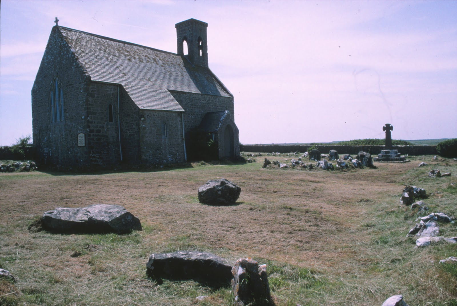
Flimston Chapel churchyard (SR92399558). There is a substantial collection of erratics in this churchyard. Some have been used as headstones for the graves of members of the Lambton Family who died in military service. Others have been left  sitting in one corner of the enclosure. All of these stones arrived in the churchyard when the chapel was renovated and re-consecrated in 1903. There are 7 of them. A pamphlet, which describes the features and memorials in the yard, printed at the time of the opening of the chapel in about 1914, gives us these vague details:
No. 1 Boulder, at the head of Lady Victoria Lambton's  grave was taken from just opposite Flimston Cottage. A 'brecciated spherultio, albite, trachyte or rhyolite.' Many occur in Pembrokeshire. This one 'seems to fit best with those of Romans'Castle in the character of its spherulites and groundmass.' Most of these appear to have travelled over 30 miles from the N. West separated from their parent rocks by St Brides Bay and Milford Haven, and by a considerable mass of high ground.........
[Flimston Cottage stood at SR927955, about 0.3 km ESE of the chapel and just north of the old clay pits.]
......No. 2 Boulder, from Pwlslaughter, which stands in the opposite North corner. [Bullslaughter, SR942944 - approximately 2.25 km SE]
No. 3 Boulder from Bulliber Farm [About 2.25 km WNW, at SR905968]
No. 3 Boulder from Merrion pond. [ About 2 km NE].
No. 5 Boulder from Lyserry Farm
No. 6 Boulder from Lyserry Farm.
No.7 Boulder from Lyserry Farm.
[Lyserry is about 3.4 km ENE of Flimston chapel, at SR9556967]

Clearly there was some significance in dragging these rocks from their resting places about the area, but quite what the intention was is unclear. It seems likely, as I have mentioned elsewhere, that they were all intended to be memorials or headstones.


Between Mewsford and Bullslaughter  Bay (SR94099405). This stone seems similar to some of those at Flimston Chapel, and indeed, the stone of St Govan's Head, mentioned above.


In the background of the picture below can be seen a target operating and observation dugout, of a type built on the range in about 1942.


There are other erratics in the area, but as yet I have not photographed them.

I am hoping to update this posting in the future with a Google Earth file that will plot the locations of the erratics I know about in the Castlemartin area. 

Do you know of any others in South Pembrokeshire?

Monday 21 January 2013

More Erratics and a Hidden Building

In the last post I mention a cup like mark on the upper surface of the stone in Loveston farmyard. I know little about what to look for in "Cup and Ring" markings, but I have ordered a book today to try and learn more:

British Prehistoric Rock Art - ISBN: 9780752425146,  Beckensall, Stan

I suspect the mark I have seen is nothing but an "accidental chip off the old block", but it is an excuse to look into the topic in more depth!


Having spent a good 45 minutes examining the Loveston stone, I then had a look at some old ruins that the farmer, Mr Morris, had pointed out to me, incorporated into a cow shed on the western edge of the farmyard. There were two bullocks in the shed, so I could not get inside, but from the outside a huge arched fireplace was visible in the north end of the shed, deep in the shadows.


Walking around the outside of the building, it was clear that the stonework of the wall was good quality, late medieval(?) masonry. The quoins were large, squared-off, limestone blocks, and the building had little foundation - sitting on an outcrop of same carboniferous limestone. The chimney stack attached to the north gable of the fragmentary remains was of classic massive South Pembrokeshire proportions. The gable was cloaked in thick ivy, so much of the detail was difficult to see. First thoughts were that it might be the remains of a small tower house, like that at Carswell near Tenby. (See http://www.pemcoastphotos.com/_photo_7481978.html for other fantastic photographs like this.)

Carswell, Nr Tenby. The ivy clad building fragment bears a strong resemblance to the gable and stack of this medievel building.


Looking at old maps of Loveston, the size of the old building is visible in the c1866 Ordnance Survey map of the area (marked A).


By 1908 this same building had been extended.


The large chimney on the north gable of the structure can be clearly seen in both maps, as it can in the 1971 map below.


In the 1971 map, the large shed just east of the ruin can be seen. (The Loveston erratic lies just to the south of this).

The earliest map above shows the possible original size of this building, sited on the side of what was originally the lane from St Twynnells Church to the coast. At the time the now ruined building would have been built, the new east-west road running just north of the farm did not exist. This road was built c.1820 to link Stackpole Court with Brownslade.


The picture below shows the remains (exciting - isn't it!!!!!) viewed from the west in January 2013. Apologies for the vivid green grass and the sarcasm.


The length of wall visible shows no very obvious breaks in build, but the cattle troughs obscure some detail. The northern end of the wall seems to have more "batter". The picture below shows the quoin on the NW corner of the building. In front of the wall is another possible erratic boulder, seemingly placed here quite recently.


I had better post this now, from a snowy and cold Suffolk winter wonderland.

I'll come back and look at this building soon and explain how it might help work out the history of the Loveston Erratic and how it came to be in the yard. Something has just occurred to me..........


Thursday 17 January 2013

The Loveston Erratic Revisited

A closer view of the Loveston stone.

I have been back to look at the Loveston Erratic, in the farmyard in St. Twynnells, Pembrokeshire. See my previous posts and the discussion at Brian John's blog, here:

http://brian-mountainman.blogspot.co.uk/2012/12/the-loveston-erratic.html

I was also able to have a good discussion about the stone with the farmer, Mr Morris. He told me that the stone had always been in the yard, as far as he could recall. about forty years ago people came "down from Cardiff" and took photographs of the stone and tried to cut a slice off it - hence the groove on the upper surface of the stone. The northern end of the stone, hidden from view in the picture I posted before, has a very clean, smooth, seemingly sawn, face. See the photographs below.

The Erratic in the farmyard at Loveston, viewed form the west in January 2013.
View of stone from the east. The book is 32 cm long.

View from north-east . The book is 32 cm x 24 cm.


View from north. Note flat "sawn" end. Attempt at cutting the stone can be seen running away from the camera.

View from north-west.
View from WNW appx.


View from WSW appx.


View from south-west appx.


View from south.


View from SSE appx.


View from south-east.

Saw cut in top of stone.

Saw cut in top of stone. Edge of book is 24 cm parallel to cut.

Another view of saw cut.
The photograph below shows (rather badly) a cup like mark on the stone. Has the appearance of having been scooped out.

Cup like mark on upper surface of stone. About 1cm deep.
Looking down on north plane face of stone.

According to Mr Morris, over the years various people have come to the visit the stone and comment on it.Some have said that it was a stone left behind whilst transporting the "Bluestones" to stonehenge. By man or by ice?

The stone was listed, but is now no longer so, but there is no intention to remove it. It is Mr Morris's belief that it gives the name to the farm - Loveston(e).

Comments and thoughts very welcome!