East Bergholt, most famously known as the birthplace and sometime home of the artist John Constable, is a beautiful village on the borders of Suffolk and Essex.
This post is prompted by a discussion that has been taking place on a Facebook group that shares photographs and information about aspects and features of the village's past. If you want to see where the village is, then please have a quick look at the East Bergholt Wikipedia page.
Local historians in and around the village are very fortunate in having access to (in normal, non-Covid-19 times) a range of maps that examine the layout of the village in minute detail, the earliest being a wonderful hand drawn map by William Brasier that dates from 1731. However the first map I will show you is taken from Google Earth and this is just to acquaint you with the layout of the settlement. Click on the image to enlarge it

The road (B1070) that runs out of the village to the south-east is known as Manningtree Road because it heads towards the small Essex town of Manningtree. As the road leaves the village it descends into the valley of the River Stour (pronounced St-oh-ur), winding down a hill to the valley floor. Leaving the village, the road steepens and follows a series of S-bends. This part of the road is known locally as "Touchy Hill" - the "ou" pronounced as in "Ow! - that hurt". The modern Ordnance Survey cartographers have mistakenly attached the name "Touchy" to a small lane or footpath that, as the hill steepens, goes off to the left. We will return to this later!
East Bergholt, in common with many villages in the eastern part of the country, had, until the early nineteenth century, large areas of heathland. This was, in the case of East Bergholt, enclosed in 1816 and leaving us with the the landscape we see today. In other words, the heath was divided into many enclosed fields, many of which that exist today. The extent of the old heath can be ascertained from the parts of the parish that have VERY straight, nineteenth century enclosure roads. The map below gives the approximate outline of the heath, based upon the evidence of the straight roads.

The heath was an open area of land that members of the community had common rights over. It was important for those villagers who were poor and had little land upon which to graze a few livestock.
The next three pictures show the village and the location marked as Touch Grave on the 1731 map. The two modern views include the viewshed, both near and far, from Touch Grave. Click on the images to see a larger picture.
 |
| Touch Grave is in the bottom left hand corner of the image The green shaded field to the right of Touch Grave is called Touch Grave Field. The map dates from 1731. |
 |
| Touch Grave is marked in the middle of the red viewshed are in the lower right quarter of the image. |
 |
| The viewshed from Touch Grave includes to the south-east Bradfield Church |
You may well ask why I have included the viewshed in the pictures above. The location of Touch Grave was selected by the Ordnance Survey as the location for a "bench mark". The surveyors used benchmarks to establish the height of the land accurately. Usually they were afixed to something that was unlikely to be moved. See this link for a more thorough explanation. I have yet to investigate if such a firm fixture exists at Touch Grave. Such benchmarks are no longer used by the Ordnance Survey, but over half a million existed at some point across the UK. They can often be seen on the walls of churches and other monuments. I wonder if there is a bench mark on Bradfield Church?
So, from the evidence of William Brasier's map of 1731 the name Touch Grave was a particular spot where a lane, marked as Procession Lane, met the Manningtree Road. The name of this spot was naturally attached to the neighbouring field. Local tales and traditions have existed that say the field was used as a burial site for victims of the plague many hundreds of years ago. The owner of the field has said that nothing unusual has been encountered when ploughing the field, so it may be that the story has evolved to fit the strange name. This map below shows the route of Procession Lane.
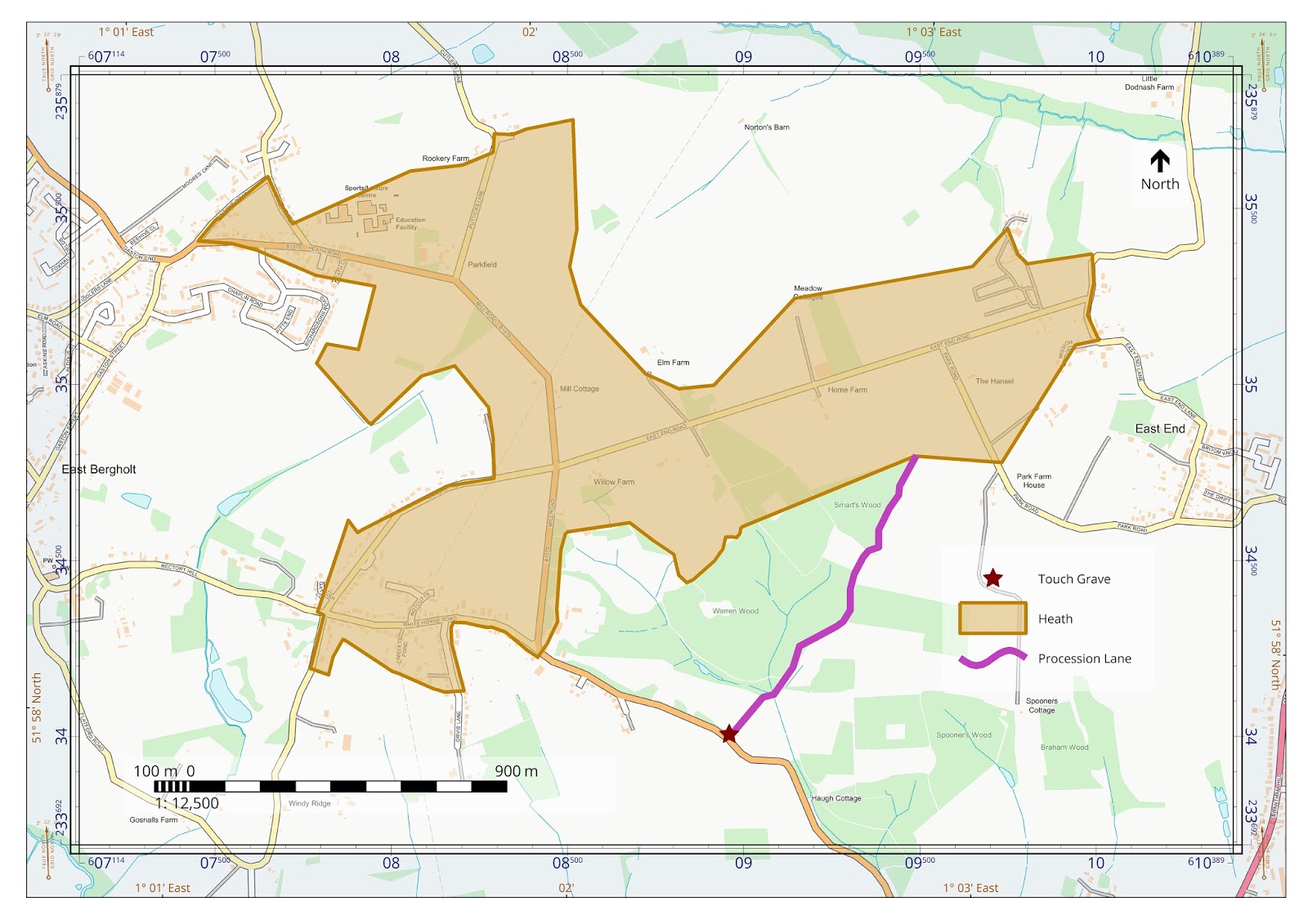 |
| The purple line shows the route of Procession Lane. |
Some may regard the name Procession Lane as being unusual, so lets have a look at that. This article may offer some pointers to the reason why this lane might have been called Procession Lane, linking the path to old burial practices. However, the path does not obviously lead towards the church except by a very circuitous route! However, burial practices would seem to have an obvious connection with the name Touch Grave.
Another suggested reason for the naming of the lane as Procession Lane is the tradition of "beating the bounds". This was a custom that was used to confirm the boundaries of a parish each year in an era before mapping was common place. Information about this tradition can be found here. In the very early 1980s I went with a friend on a "beating of the bounds" walk in the parish of Milden in Suffolk. Among some good memories was the vision of groaning trestle tables in the village hall at the end of the walk - game pie and home made cakes of all sorts!
The map above shows Procession Lane meeting the heath of East Bergholt. The map below shows the path continuing beyond the heath, into neighbouring parishes.
 |
| The continuation of Procession Lane to the north. |
From the path taken it would seem unlikely that the lane was part of the route for "beating the bounds". It seems more likely that it was an old route that went across country, from the river Stour to Ipswich, but why is it called, for at least part of its length, Procession Lane?
Do you have any ideas? Also, what about the origins of the name Touch Grave? If you have any ideas about either of these points then I would be glad to hear from you!
This link will take you to the Bing Mapping website where you can see the Ordnance Survey's modern depiction of East Bergholt.
Perhaps there will be a second part to the story....I hope so!