Thursday, 10 March 2016

The Park - A Rare Gem at Merrion - Part 6


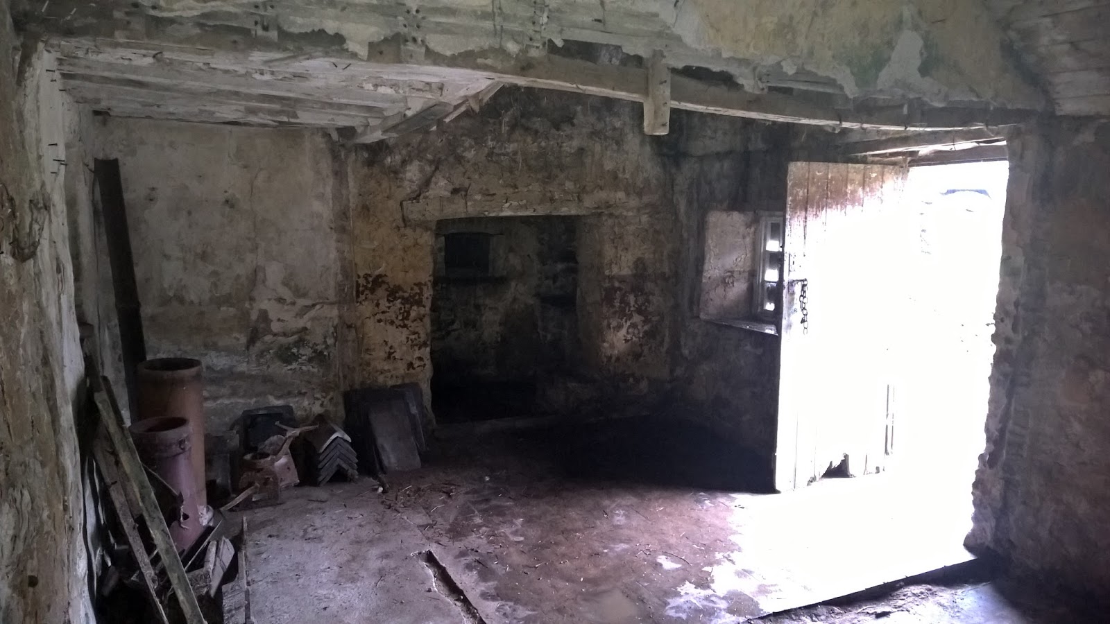
The next few photographs show interior views of the fireplace and, oven and stack in the north gable of The Park.

The opening to the oven/fireplace is a about 4-5ft tall., with a wooden beam above. There is another wooden beam running across the floor of the opening. In this photograph a small stone platform is visible to the right of this opening. At the rear of the small "room" can be seen the doorway to the bread oven and to the right (not clearly visible here) is a fire grate with a "fitted" stone above.
The change in the colour of the lime wash on the gable wall betrays the level of an inserted ceiling and probable crog loft, now lost.


The oven visible today seems to have been a later insertion into the rear of the massive chimney


The oven has a circular domed top and is constructed from what appear to be cream coloured firebricks. The floor of the oven, where the burning wood would have been spread to heat the oven, seems to be of thick flagstone construction. There is no door surviving for the oven. To the right of the oven is a smoke blackened alcove with a small grate, again made of cream firebrick,  which may have been used for cooking or heating water. Now it seems to have a fitted stone shelf inserted above it of uncertain purpose.


The chimney stack is of massive limestone construction, blackened by smoke and soot. The western and back wall of the stack are vertical. The east and front walls taper until all meet to form a rectangular, near/y square flue. within the "fireplace" itself, on the western wall their is some irregular stonework, now covered in lime wash that might suggest the removal of an oven. the wall here seems, at first inspection, to be very thick. Perhaps with enough depth to accommodate an earlier oven? Similarly, the grate in the eastern wall seems to be a later insertion.


The build of the entire fireplace and stack has the appearance of being of better quality than much of the rest of the house.


In the next post I will look at the fireplace in relation to the northern part of the building.

See also:

The exterior of The Park


Tuesday, 9 February 2016

The Park - A Rare Gem at Merrion - Part 5


The one way into the cottage is a door in the east facing wall of the house. If you are tall you will need to duck!


Looking down at your feet as you step over the threshold onto the quarry tiled floor, there are the grooves in the door frame to accommodate a drop down board - not to keep flood waters out (as in coastal towns like Aldeburgh in Suffolk), but, according to the owner for whom it was installed,  to stop a crawling baby leaving the cottage un-noticed!


 Below is the view of the north end of the cottage. The lathe and plaster partitions have been removed - notice the scar in the floor and the changes in wall colour wash.

The north end of The Park, looking towards the large "fireplace" and oven.


The same view as above, showing the position of partitions and doorways that have now been lost.

The view below is similar to those above, but taken on another visit, when it was raining hard!! The water was dripping through a hole in the roof near the gable and running down the floor, finding those aras that were slightly sunken dues to decades (centuries??) under foot. Again notice the scars in the floor where partitions formally stood. The small room on the left looks like it might have had a mortar floor. Also notice the irregularity of the west wall (left of picture) when compared to the line of tiles on the floor.

The north end of The Park. See notes above.

Longitudinal section of The Park
A good way of trying to understand how a building "works" is to try and reconstruct it with SketchUp.

The pictures in this post are of a 3D virtual model of The Park put together from photographs and a ground plan of the cottage. Whilst not accurate to scale, they do give a fair impression of how the house might have looked. 

The next post will look at the "fireplace and oven" in the north gable.


Tuesday, 26 January 2016

The Park - A Rare Gem at Merrion - Part 4


A Closer Look at the Exterior of the House and its Setting

See also:
The first photograph below is a view from the north-east of the cottage that shows the conical. semi-circular oven projection to good effect. Originally this would have been covered in random slates, but these have fallen off and lie around the base of the oven. The owner has protected the interior of the oven by capping it with a cement mix - a good short term measure to keep the rain from seeping through the porous limestone and damaging the fire bricks within, but reinstatement of the slates with a lime based mortar, allowing the stonework to breathe, would be a better longer term solution. The slate covering of the lower part of the chimney stack gives protection to what was probably an earlier oven off to the side of the main stack. This will become clearer when we look inside the house. After each group of "real" photograph is a view from a similar vantage point that shows an approximate 3D model of The Park showing what it could look like or what it might have looked like.


The next two photograph, taken from the north-west shows how an elder(?) tree has taken hold in the stonework. Killing this off chemically and allowing the root structure to die before attempting to remove it will stop the roots of the plant doing more damage to the old structure by prizing the stones apart.


The fourth  and fifth photographs are taken from the south-west.


The step in the roof line marks the end of the thatched roof and the start of a (probably) early to mid-nineteenth century rebuilding of the lower end of the house. The roof over this part is of uniform sized slates, with a small coal fireplace and its flue (with stack) built into the southern gable of the house.


The chimney stack atop the southern gable seems to be built of limestone. The ground level on the western side of the house is much higher than that on the east, and large stones in the hedgerow and underfoot may indicate that there may be the footings of a "lost" wing of the house beneath the turf and debris build up. Only careful excavation can demonstrate whether that is true or not, but there are clues that this might be a possibility on the inside of the cottage.


The photograph to the left, above, shows a closer view of the southern gable of The Park. There is a crack that runs up the wall on the outside, along the line of the flue, and some stones appear to have been dislodged. There are seemingly still remnants of the original lime "render". The photograph on the right above shows the more modern slate roofing of the southern part of the house. There is also an indication of the higher ground to the west, behind a partly revetted wall.


In the shot immediately above, the various lime wash coatings can be seen, with a light ochre colour seeming to predominate. Beyond this, the lateral chimney stack is smothered in ivy and a sycamore tree has taken root at its base. The upper parts of this stack are brick built and the red brick is visible through the growth. This stack must have been heightened, or more likely repaired, after the mid-nineteenth century.


Next time we will begin to look at the interior of the house.


Friday, 22 January 2016

The Park - A Rare Gem at Merrion - Part 3

A Rare Survival of a Seventeenth Century Cottage in St. Twynnells, Pembrokeshire


Starting to Look at the House and its Setting

The Park - A Rare Gem at Merrion - Part 1

The Park - A Rare Gem at Merrion - Part 2

The owners of The Park were kind enough to let me have a look at the house and its attached land. The place is a total delight and a very rare survival. The owners have made valiant efforts to keep the weather out by covering the building with tarpaulins and capping some of the stonework, even if the result is not entirely pleasing to the eye.

The layout of the site is below. I will talk more about the setting in another post.


The first three photographs are of  the east facing side of the house, looking across what was the garden. The third photograph is one taken in the 1980s for comparison. The roofless building to the right is the old "barn"(?).


In the pictures above there is a drop in the ground level between the garden and the immediate front of the house, there being a dry stone wall revetment holding the ground of the garden back. This can be seen, covered in brambles just off to the left, in the photograph below. Trees have taken root in parts of the fabric and have caused some cracking. In this view around the foot of the lateral chimney stack. The drop in level from the garden can be seen to good effect in the old photograph at the end of Part 2 of this series of blogposts.


Below here is an attempt at reconstructing The Park in Sketchup - again a view from the east. It is not a measured reconstruction, but produced as best I can from photographs. I think the gable chimney looks a bit too big! Notice the projecting conical oven in the north gable. Also notice the thatch, which still survives under the tin roof!!


Next time we will look at the west wall of the house before later, stepping inside.


Tuesday, 19 January 2016

The Park - A Rare Gem in Merrion - Part 2

A Rare Survival of a Seventeenth Century Cottage in St. Twynnells, Pembrokeshire


A Brief History of The Park

Also see:

The earliest map of The Park comes from a Stackpole Estate map book of  1786. The holding has remained the same since this date, with access to the south. In 1786 the long, straight road that now runs from Samson Cross to Brownslade did not exist and the farms and cottages of this part the Castlemartin peninsula were connected by an intricate network of lanes and paths, many of which no longer exist. One such land followed the parish boundary between St Twynnells and Warren parishes, forming the western edge of The Park.


 We get information about the land abutting The Park from this early map too. To the west the land was part of the tenement known as Merrion, a farm that was to disappear by the mid nineteenth century. To the north and south were the lands of Mr Freeman, probably of Crickmail. At this date, Crickmail was not part of the Stackpole Estate. To the north was the holding called Venn.

The schedule that accompanies the 1782 map shows that the holding was just over 8 acres and had a rental value of £5 per year.

A deed of 1789 in the Cawdor  collection (Cawdor Handlist II Box 2/211), until recently in the care of Carmarthenshire County Archives, reveals that:


Messuage and Lands late part of Venn, now called Park, now in the tenure of Abraham Evans for £5/5/0


This document is important in telling us that The Park was part of a large holding known as Venn. The Google Earth image below shows the extent of Venn and The Park at this time.


From the deed above it would seem that the tenement of Venn was divided up in about 1780, with about one quarter of Venn being given to another tenant. This portion became known as Park or The Park.

Prior to this division of Venn, we know that in 1725 (Pemb Archives: D/Angle/2) the property was part of:


Castlemartin Lordship, St Twynnells parish. One messuage and tenement by the name of Ven in the possession of John Evans and Widow Poyer under the annual rent of £7/2/6. Owned by John Campbell.
So it would seem that the Evans family lived at The Park, taking it as a holding in its own c1780. By 1803 we read in a rough list of arrears in Cawdor Campbell Box 271, a rental for 1803 that:
George Evans arrears of £18/16/0, since 1897(?). Very Poor, no hope. [Ticked as no longer being a tenant.]
 In the same rental John Dawkins is the tenant of Park, paying the same rental as his predecessor - £5/-/-. He was also the tenant of Venn.

By 1810 the rent had increased to £5/5/- and John Duberlin was tenant and the family remained  so until at least 1838, the time of the Tithe Survey of St. Twynnells parish, when the tenancy was held by Mary Duberlin, probably John's wife.

The first census when individuals households were recorded, in 1841, throws more light upon the number of people who lived at The Park at one time. In the summer of 1841 the head of the household at the Park was William Thomas, 40, an agricultural labourer who had hailed from Lampeter Velfrey. To keep him company there was his wife, Mary,  and four children, with a fifth child who was probably visiting on the day the enumerator called.

William remained a tenant until after 1881. By that year he was working as a garden labourer at the age of 81. He lived with his daughter and her young family. She had married, in 1877,  Peirce Phillips, was also a garden labourer and it was Peirce who took over the tenancy when his father-in-law died in 1885. Peirce was not a local man - he was born in Warren!  William was buried, in sight of his home, at St. Twynnells church in 1885.

Peirce and his family were still living at the Park in 1911, he being a horticultural labourer and his son an auxiliary postman. It may be members of the Phillips family who appear in the glorious photograph below.


I stop there as the trail runs cold through lack of research. It would seem, however, that the owners in 2015 have links to The Park back at least to the 1950s.


In the next post I will look more closely at The Park today.


Monday, 18 January 2016

The Park - A Rare Gem at Merrion - Part 1

A Rare Survival of a Seventeenth Century Cottage in St. Twynnells, Pembrokeshire

The Distinctive Vernacular Style of Rural South Pembrokeshire


In the late 1970s and early 1980s, I worked, on and off, on the Royal Armoured Corps Range at Castlemartin, Pembrokeshire. It was great! I was a casual Range Warden, which involved putting up targets, manning the sentry posts and lookouts, being a presence on the firing points and a having access to some of the best coastline and countryside in the whole Kingdom! I loved it!

One of the many enjoyable jobs, was accompanying one of the permanent staff wardens - Artie Gough - callsign "Watchdog"- on his regular tasks of checking the gates and boundaries on the range. He was a font of knowledge about the place. Pre-Second World War, he had been one of the gamekeepers on the Stackpole Estate and he told me much about the houses, families, habitats and wildlife of the place.

Amongst one of the places he mentioned, was a cottage called "Park", which whilst not within the range boundary, was a derelict "old house" like many that had been consumed by the War Office in 1939. A good description of these lost buildings is the brief and hurried survey that Sir Cyril Fox undertook just after the War Office moved onto the land at Castlemartin, or as the training area was known then - AFVR Linney Head.

The image below shows one of these cottages - this at Castle Lady in Castlemartin, otherwise known as Drayton.


So, during one lunch hour on the range, I went out through the gates of the camp, crossed the road near Treforce and the sewerage plant that serves the camp at Merrion, and walked up the track to "The Park". Later, that evening, I returned with a camera and took the photograph below. I was very worried that I might be caught!!


The house is aligned roughly North to South. In the photograph, taken from the east, the older part of the house is on the right, with a 19th century addition or rebuilt section to the left, roofed in slate. The northern gable has a large(ish) chimney stack, in this photograph, covered in ivy. To the left of the door is a "lateral" chimney stack, with its upper levels (re?)built in in brick. The corrugated tin roof is an indicator that the cottage was originally thatched, the thatch being replaced, or so I thought, when it became decayed.

At the time, I had just bought " Houses of the Welsh Countryside" by Peter Smith - one of those books that is a landmark in the study vernacular houses ("houses of the people") in Wales and the UK. The Park was an example, in small scale, of one of the typical yeoman farm houses that were, in their time, common-place in the Castlemartin area.

About a quarter of a mile to the south of The Park are two examples of these yeoman farmhouses. The best example is the holiday cottage called Thorne, which sits on the eastern edge of  a small cluster of buildings at a settlement that was known as Hayston. Thorne, until about 1826, was the home of the Moody family, who were copyhold tenants of the Manor of Castlemartin, in the parish of St Twynnells. They had lands scattered all over the parish - as was the norm for many land holders in the area up until the 18th century - their largest parcels being near Vallast Hill and near Trenorgan. The land at Vallast Hill was on Old Red Sandstone, less well drained than the more fertile land at Trenorgan on Carboniferous Limestone. This arrangement was a possible example of how the holdings within the manor were equably distributed across both the good and not so good soils. The Moodys also had rights to the resources of Castlemartin Corse, which was later drained by John Mirehouse of Brownslade. I digress!

The view from St Twynnells church tower in about 1987 of Thorne and Hayston. Thorne is left centre, with part tin roof and Hayston is the large white farmhouse right centre. The Park is just off the picture, bottom left.

Thorne looking from the south-east
Hayston looking from the north-west

The centre ridge chimney stack at Hayston has been much messed around with, but its similarity to the one at Thorne shows that both houses are originally of a similar date. Probably early 17th century, perhaps even late 16th century.

Hayston was improved by the Stackpole Estate as the homestead for a fairly large estate farm, Thorne on the other hand, when relinquished by the Moody family is about 1826, became an estate cottage and was subsequently remodelled into two dwellings. From the north, Thorne reveals more of its pedigree, as shown in the photograph below.


Here we see the fine lateral chimney on the north side of Thorne. The wall on the viewer's side of the stack is that of a lateral out-shut. The tin roof indicates that the older part of the house was probably thatched. The chimney to the far left is part of the nineteenth century conversion of the house into two cottages.


The original door way into the early house, set along side the lateral (on the side of the building) chimney. The later doorway into the second dwelling is to the left. Some rebuilding of walls has taken place too.


The Park has many of the features of Thorne, but on a much smaller scale. Large gable chimney with projecting oven, A lateral fireplace and chimney and a seemingly lateral out-shut.

Other houses locally that seem to embody some of these features, if not all, are mentioned below.

Bosherston, Church Cottage. This was demolished in 1984, but had very many features similar to The Park. It had been overlooked by the planners and conservation bodies and was not listed.


The enigmatic rectangular part projecting from the side wall is either a lateral out-shut, or more likely, the base of a now removed lateral fireplace and chimney. The large stack, covered in dead ivy at the far end of the building, has a semi-circular oven projection, like The Park, (not visible in this photograph). A fuller comparison will be made with The Park in a later post.

Parsons, a very ruinous house in Castlemartin parish, also has a semi-cicirular oven projection. Little remains of the house, but it almost certainly dates form the seventeenth century if records for Castlemartin are to be believed.

The photograph below shows a rough sketch plan of the remains of Parsons about 35 years ago, as surveyed by this blogger.

Parsons, Castlemartin

...and another example of a projecting oven is at Dover, in Bosherston. This is easily visible from the road.


There is also another cottage with a similar oven at Thornston, just down the road towards St Govans Head. This building has similarities to Cold Comfort in Warren.

The projecting oven is believed to be an addition to an earlier chimney stack, and this seems to be the case at The Park, as we will see later.

In the next post on this topic I will look at what I have been able to glean about the history of The Park.

Meanwhile, below is a map to show the locations of the buildings mentioned in this post. All lie on private land.


Tuesday, 14 July 2015

Sway and an Idea for Hospital Bedside Tea.

Having had to visit Withybush Hospital in Haverfordwest lately, the thought below occurred to me!

It is always good to have a cuppa and a chat. Perhaps this idea would make visiting time at hospital seem more like normality for all concerned? Comments welcome.


Tuesday, 14 October 2014

Flash! Flash! Flash! Flash! Flash! (Part 1)


Watching the Birdie!!

How do you take a photograph, from a high speed aircraft at night and at low level? You use a flash!

A lot of my plane spotting, in the 1970s, was carried out from the south facing bathroom window of our house in Pembroke Dock. From here you had an expansive view of the sky towards the Royal Armoured Corps Range (RACR) Castlemartin. This was before the ash trees, with their rookery, became so tall that they blocked the view.


Location of map extracts below in UK

You could not actually see the land surface of the range - that was about 4.5 miles to the south and behind the next row of houses on the skyline 400 yards across the valley. The line of chimney pots provided good markers on the horizon!

We were used to the sound of gun fire from the range and there were usually "night shoots" twice a week, which also lit up the southern sky with orange flashes. However, I soon began to notice that on some nights - often Tuesdays and Thursdays in the winter - that the signature of the "firing" was different. Five equally spaced intense white flashes, followed by five dull thumps. This post is about these flashes and begins to explain what was going on.

Fig. 1: An extract from an Operational Navigation Chart showing Pembrokeshire, Wales, UK
This is from sheet ONC E-1 Edition 8-GSGS (1993)
The chart above shows the important navigation features in and around Pembrokeshire c1993. RACR Castlemartin is the danger area marked "EGD 113". Most of the area is over the sea, with a much smaller portion lying over the Castlemartin peninsula in South Pembrokeshire. The danger area to the east, "EGD 115" is the anti-aircraft artillery range at Manorbier. Pembroke Dock is the yellow blob just above the figure 731 which, incidentally, marks the old smoke stack at the Pembroke Power Station. This stack has now been (spectacularly!) demolished.

Both Royal Air Force (RAF) and United States Air Force (USAF) used the range for night training sorties, as well as the occasional day time mission, often as part of larger exercises and competitions such as Exercise Lifeline and the annual NATO Royal Flush contest.


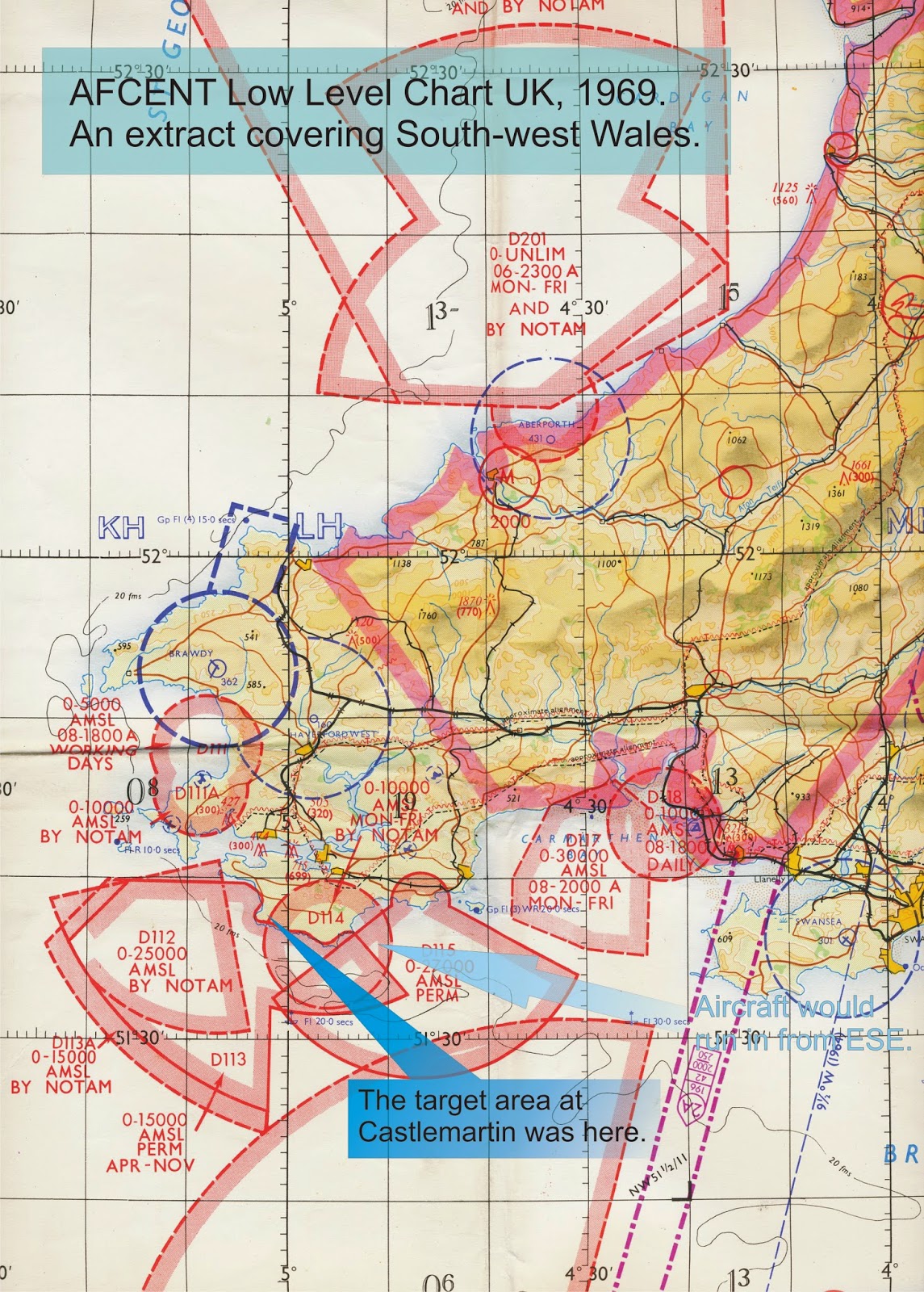
Fig. 2: The layout of ranges around Pembrokeshire in about 1969.
The annotations show the line of approach and the target area at Castlemartin,
which was west of the Warren to Stack Rocks Road, over Range West.

The nights when the range was booked by the RAF or USAF were always published in advance in the "Warning Notice of Firing" for Castlemartin in the local press, so I knew when to hang out of the bathroom window with my metaphorical anorak on!

The American aircraft (RF-4C Phantoms)  often arrived during dusk, before the sky became totally dark. 


Fig. 3: Unit badge of the 1st Tactical Reconnaissance Squadron,
one of the constituent units of the 10th TRW
They were usually from the 10th Tactical Reconnaissance Wing (TRW) at RAF Alconbury in what was then Huntingdonshire. The 26th TRW from Zweibrucken in West Germany probably also used Castlemartin, but I cannot be sure.

The RAF always arrived on scene long after the sun had set.The aircraft were Canberra PR Mk 7s or PR Mk 9s from RAF Wyton, just down the road from the Americans at Alconbury, or the RAF "clutch" airfields in West Germany - Laarbruch, Gutersloh and Wilderath.


Fig. 4: RF-4C of 10th TRW getting airborne from RAF Alconbury.
Notice the grey/white naval style colour scheme and
buzz number FJ-077. c1965
The sorties first started in about 1965. At this time the 10th TRW at Alconbury were just receiving their brand new RF-4C Phantoms, which at the time had a grey/white scheme complete with old style "Buzz numbers" on the fuselage.

To the right  (Fig. 4) is a photograph of such an aircraft getting airborne from its home base in Huntingdonshire.

The RAF sorties were flown by various versions of the Canberra. The photograph below (Fig. 5) shows the PR Mk. 7 version of this long-serving type.


Fig. 5: Canberra PR Mk 7, in a camouflage scheme worn at
the end of its RAF career.

For more information about the Canberra and its photo reconnaissance role in the RAF see the website below.

http://www.airrecce.co.uk/postww2/ac/Canberra/Canberra.html


Fig. 6: 13(PR) Sqn, RAF - their Canberra PR Mk. 9s were the last RAF Canberras to carry out photo-flash sorties.

In the second part of this post I will describe what went on over the range in more detail.